
Unmanned Aerial Systems (UAS) Camera Calibration
We have followed the progress of ASPRS regarding the guidelines for the calibration of the UAS system. To date, the Calibration Committee has adopted the position that the UAS camera should be subject to a careful, accurate metric calibration before attempting further calibration of the system. It is likely that the full in situ approach to system calibration requiring high accuracy positioning of each exposure station will not be realistic considering the weight and cost of current GPS receivers. In addition, the lower altitudes of UAS operations require an even higher spatial accuracy if a reasonable error to flight height is to be maintained.
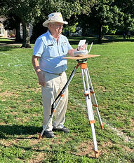
Accordingly, Topo Photo, Inc. is in the process of developing an inexpensive but accurate approach to metric camera calibration for the typical UAS camera. the approach is based on the array of accurately measured ground targets (100+) and a stationary, accurately controlled exposure station. The targets were measured by means of a calibrated tape resulting in a trilateration network adjustment root mean square of less than 1mm. Elevation was measured by spirit levels to a similar accuracy. With the current station is a bot more than four meters above the hanger deck.
Although close range camera calibration has been conducted in this range for many years, refinements are currently underway to more closely adapt to the special requirements of the UAS camera such as stability testing and temperature correction models.
For further information concerning UAS camera calibration, we suggest that the ASPRS Camera Calibration Committee be contacted.
Nikon Camera in Place on the Hanger Remotely Controlled Mount
UNMANNED AERIAL SYSTEMS RECONNAISANCE
Topo Photo, Inc. recently added Part 107 photography and videography services that can be applied to natural resource monitoring, infrastructure, and agriculture inspection.

_jpegTopography.jpeg)

